Geology
· Visual Evidences
· Scientific Methods

![]()
| The Formation of the Himalayas
The Himalayas are known to be youngfold mountains. Young, because these have been formed relatively recently in the earth's history, compared to older mountain ranges like the Aravallis in India, and the Appalachian in the USA. They are known as fold mountains because the mountains extend for 2500 km in length in a series of parallel ridges or folds. |
The accepted theory about the formation of the Himalayas started to take shape in the year 1912 when German meteorologist Alfred Wegener developed his Theory of Continental Drift. According to Wegener, the earth was composed of several giant plates called tectonic plates. On these plates lie the continents and the oceans of the earth. The continents were said to have formed a single mass at one point in time. From this single mass, today's continents have "drifted" apart from each other over a period of millions of years.
We pick up the story about 250 million years ago. During this time, all the earth's land was a single super continent called Pangea, which was surrounded by a large ocean.
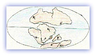 |
| The continents, 180 Million years ago. Credit: Mahabir Pun |
Around 200 million years ago (also known as the Middle Permian Period) , an extensive sea stretched along the latitudinal area presently occupied by the Himalayas. This sea was named the Tethys. Around this period, the super continent Pangea began to gradually split into different land masses and move apart in different directions.
As a result, rivers from both the northern Eurasian land mass (called Angara) and the southern Indian land mass (called Gondwana) started depositing large amounts of sediments into the shallow sea that was the Tethys. There were marine animals called ammonites living in the sea at the time. The two land masses, the Eurasian and the Indian sub-continent, moved closer and closer. Indian plate was moving north about at the rate of about 15 cm per year (6 inches per year).
The initial mountain building process started about seventy million years ago (or the Upper Cretaceous period) when the two land masses (or plates) began to collide with each other. As a result, the already shallow seabed rapidly folded folded and was raised into longitudinal ridges and valleys.
 |
| The continents, 65 Million years ago. Credit: Mahabir Pun |
Soon afterwards, about 65 million years ago (Upper Eocene Period), came the second phase of mountain building. The bed of the Tethys started rising again. The sea retreated, and the sea bed was elevated into high mountain ranges.
Later, about 25 million years ago (Middle Miocene Period) came another mountain building period which led to the formation of the low Shivalik ranges. After this, periodic mountain building phases occurred as the Indian plate pushed against the Eurasian plates which led to the Himalayan ranges rising further. The last major phase occurred 600,000 years ago.
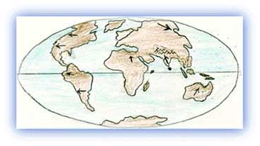 |
| The continents, today. Credit: Mahabir Pun |
Although the phase of major upheaval of the Himalayas has passed, the Himalayas are still rising, albeit at a much slower rate. The Indian plate is continuously moving north at the rate of about 2 cms every year. Because of this reason the Himalayas are rising at the rate of about 5 millimeter per year. This means that the Himalayas are still geologically active and structurally unstable. For this reason, earthquakes are a frequent occurrence in the entire Himalayan region.
It has to be understood that it is impossible to detect the movement of the plates and uplifting of the Himalayas by casual observation. However, a modern technology called Global Positioning System (GPS) has made it possible to measure even such a slow movement of the plates.
The Alps in Europe are another example of a mountain chain that formed due to the collision of tectonic plates.
All rights reserved